MERCED RIVER (Ahwahneechee: Wa-kal-la; Spanish: El Río de Nuestra Señora de la Merced), Yosemite National Park, California |
||
 |
||
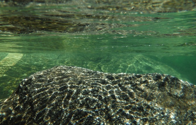
Underwater view of a granite boulder, similar to the granite cliffs above. Photo by Derek Irland. |
||
————————————————————————————————— Special thanks to Indian Cultural Program Interpreter Phillip Johnson, National Park Service Ranger Shelton Johnson, and Environmental Educator Dakota Snider, all of whom are part of the Yosemite National Park Service. Thanks also to Lisa Robert, with her encyclopedic knowledge of rivers. —————————————————————————————————
Currently, (one of my favorite words!), my headwaters lie above 8,000 feet (2,438 m), and I joyfully run wild through canyons and gorges at the beginning of a 145-mile (233 km) course that has helped to carve this spectacular landscape. I was an infant ten million years ago when the Sierra-Nevada range began to rise. Glaciers contributed to sculpting the high elevations of my watershed, and one million years ago, the advancing ice scooped out this U-shaped valley. When the glacier melted, a lake formed behind the terminal moraine, and as it eventually filled with sediment, it created the present valley floor. |
||
 |
![2b. Merced River (Wa-kal-la) at a site called Devil's Elbow, with El Capitan (Tu-tok-a-nú-la) looming overhead [ed 2]](Resources/elcapitan.jpeg) |
|||
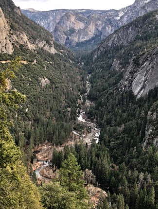
The valley that the Merced River helped to carve, with Bridalveil Falls in the distance. |
Merced River (Wa-kal-la) at a site called Devil’s Elbow, with El Capitan (Tu-tok-a-nú-la) looming overhead. |
|||
During my lifetime, I’ve witnessed successive human cultures that stretch back more than 7,000 years. Generation after generation of indigenous peoples relied on me for water and food. The Ahwahneechee (including the Southern Sierra Miwok and Paiute) tribes lived in villages along my shores, constructing their conical homes, or umachas, of pine poles, with incense cedar bark insulation and a hole in the top for smoke ventilation. They slept on bear and deerskin bedding, with blankets woven from the fur of smaller animals. These were people who respected and cultivated groves of black oak for the acorns, which they pounded into flour for mush or acorn biscuits. They were skilled hunter/gatherers, relying on a variety of game, and the greens, seeds, nuts, roots and berries of all seasons.
Further downstream from Yosemite, near my confluence with the San Joaquin River, a weary group appeared on my banks, thirsty and starving, so low on provisions after some unimaginably harsh journey that they declared me El Río de Nuestra Señora de la Merced or “River of Our Lady of Mercy” in their native tongue, Spanish.
For so long I had been Wa-kal-la, a musical word that simply means “the river.” All of the famous places within this National Park once had Ahwahneechee names. This entire valley, which I carved with the force of my water, was Ah-wah-nee, (“place of the gaping mouth”), consequently the Ahwahneechee are the “people of the place of the gaping mouth.” Bridalveil Falls was named Po-hó-no (“a puffing wind”); Half Dome was Tis-sé-yak, (“woman stained with tears”) for its dark vertical stripes that are composed of lichens; El Capitan was named Tu-tok-a-nú-la (“inchworm” or “measuring worm”) for it is said that two bear cubs were sleeping on an enormous flat rock near my shores when the rock began to grow up towards the moon. The mother bear asked other animals to rescue her cubs, but none succeeded until a small inchworm crawled to the top and led the two babies down to their mother. |
||
![3b. Merced River and Half Dome (Tis-sé-yak). Photo by Derek Irland [ed]](Resources/halfdomephotobyd.jpeg) |
 |
|||
Merced River and Half Dome (Tis-sé-yak). Photo by Derek Irland. |
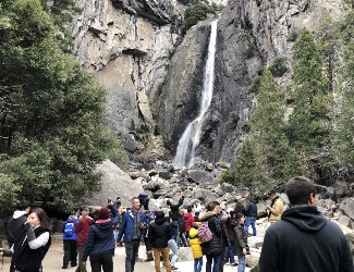
Tourists from around the world photographing Yosemite Falls. |
|||
Among the new settlers, I was referred to as “the Merced,” and the region all around me became “California.” Then, in the year 1849, greed for small gold nuggets brought miners and treasure hunters by the thousands to the stream banks of the Sierra-Nevada, and here, as in most other places, the indigenous population was threatened, destroyed, or pushed out. By 1851, troops of the Mariposa Battalion, a California State Militia, began burning tribal villages and destroying Ahwahneechee food supplies. The soldiers called their “newly discovered” valley “Yosemite,” believing that to be the name of the local inhabitants. (Ironically, the Ahwahneechee word yohhe’meti actually means “some among them are killers.”) In less than a decade, tourists were arriving by stagecoach, and land in the valley belonged mostly to non-natives.
Fortunately, human thinking ebbs and flows, just as water does, and soon there came a man who spent a lot of time in my company. John Muir was an American author, naturalist and environmental philosopher who said of Yosemite: “It is by far the grandest of all the special temples of Nature I was ever permitted to enter.” His writing about wilderness began to enlarge people’s idea of what is valuable, and he helped to found the environmental organization, the Sierra Club. Muir argued for the preservation of the Yosemite Valley, lobbying Congress until its lawmakers created a National Park here in 1890, the third such commons in the young nation, following Yellowstone in 1872, and Sequoia, also in 1890, but a week before Yosemite.
The Park now brings ever greater numbers of people to this valley. They come with their cameras to watch me plummet over the cliffs at Nevada and Vernal and Yosemite Falls. Whew, that is quite the exhilarating ride, freefalling such distances! |
||
 |
![2b. Merced River (Wa-kal-la) at a site called Devil's Elbow, with El Capitan (Tu-tok-a-nú-la) looming overhead [ed 2]](Resources/ponderosapines.jpeg) |
|||
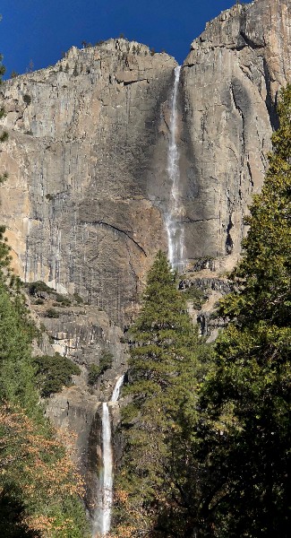
At 2,425 feet Yosemite Falls is one of the tallest waterfalls in the world. |
Majestic Ponderosa Pines. |
|||
 |
||
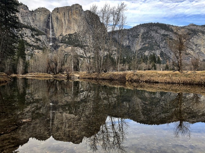
Yosemite Falls reflected in the Merced River. Photo by Derek Irland. |
||
Today, I and the several creeks that join me inside the Park’s boundaries -- Tenaya, Yosemite, Bridalveil, and Cascade -- are prized for our beauty and our natural ways. My human neighbors accept that this alpine climate produces heavy snow in the Sierra, and that flooding is a possibility when all that snow melts. In January of 1997, I raged far beyond my banks. Many facilities in the valley were inundated. After portions of the El Portal Road were damaged the National Park Service began the rebuilding process by upgrading and widening the road, which had historically been unsafe. Even after the flood, there was no talk of dams or levees to confine me, because in 1987 Congress designated 71 miles (114 km) of my body as a Wild and Scenic River, and under federal law, I am free to swell or diminish, and to sweep from side-to-side across my natural drainage, as every stream desires. April 2018, brought another flood to the valley when I rose as high as 13.73 feet (4.18 m). The deluge, caused by warm tropical moisture from a strong Pacific storm called the “Pineapple Express”, closed the Park for two days when roads were under two to four feet of water. My waterfalls exploded into full glory. But my waters receded quickly and soon Yosemite was re-opened and staff began the cleanup process. |
||
 |
![2b. Merced River (Wa-kal-la) at a site called Devil's Elbow, with El Capitan (Tu-tok-a-nú-la) looming overhead [ed 2]](Resources/highwatersign.jpeg) |
|||
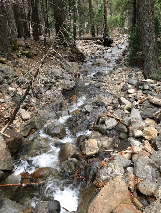
Bridalveil Creek, one of the numerous small tributaries flowing into the Merced River within Yosemite National Park. |
Derek Irland reaching toward a sign showing high water level mark of the flood on January 2, 1997. In the background, the Merced flows at its normal level. |
|||
I am blessed to have abundant fauna who visit my shores often. Numerous birds thrive here including mourning doves, Cassin’s finches, dippers, woodpeckers, great blue herons, Steller’s jays, red-winged blackbirds, red-tailed hawks, cliff swallows, canyon wrens, mergansers, bald eagles, and the ever-present scavenger ravens who are always looking for leftovers from the tourists. Mammal species who come for a drink include Sierra hares, raccoons, bats, skunks, beavers, coyotes, bobcats, black bear, and Sierra bighorn sheep. The tiny pika chatters and gathers twigs for its nest to help them get through the cold winter months. Mule deer wander the grounds of the park and have become almost oblivious to human encounters. The trees that live within my watershed include the California black oak, incense cedar, white and red fir, western juniper, and several groves of giant sequoia trees. Some say that the majestic ponderosa pines have a warm smell similar to vanilla, while the Jeffrey Pine has bark that might have the aroma of butterscotch. I also sustain many small meadow ecosystems that contain luscious wildflowers. |
||
 |
![2b. Merced River (Wa-kal-la) at a site called Devil's Elbow, with El Capitan (Tu-tok-a-nú-la) looming overhead [ed 2]](Resources/muledeer.jpeg) |
|||
Infant mule deer. |
||||
![2b. Merced River (Wa-kal-la) at a site called Devil's Elbow, with El Capitan (Tu-tok-a-nú-la) looming overhead [ed 2]](Resources/ravens.jpeg) |
||||
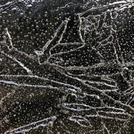
Ice patterns on a frozen segment of the Merced River. |
The ever-present scavenger ravens. |
|||
I have become a popular recreational destination with the prevalent activities of camping, hiking and fishing occurring along my shores. It’s fun to hear the screams of passengers in boats as they shoot downstream while whitewater rafting upon my spine. Over four million tourists visit Yosemite each year, which can be a tad overwhelming, so I am always glad when the sun goes down and I can glide alone under the night sky with the stars watching overhead.
It is gratifying to know that there are groups working on my behalf. The National Park Service and the University of California Santa Barbara are cooperating on a three to five-year project that began in the summer of 2016 to preserve and restore my system as I flow through Yosemite. The project hopes to provide engineering and scientific information to assist in both long and short-term efforts to protect me and enhance the values of a Wild and Scenic River. One of the primary criteria for eligibility of being designated Wild and Scenic is the presence of “outstandingly remarkable values” that make a river worthy of special protection. These values can include “scenery, recreation, fish and wildlife, geology, history, and culture.” Luckily for me, I possess all of these values, which is cause to celebrate each day!
The collaborative team plans to assess the human impacts of heavily visited areas. Data is being collected along my riparian zone to address the geomorphic, hydrologic and vegetative conditions. Specific goals of the Merced River Plan include; “Protect and Enhance Ecological and Natural Resource River Values, Provide Opportunities for Direct Connection to River Values, Establish a User Capacity Management Program, and Determine Land Uses and Associated Developments within the river corridor.” Also, the Yosemite Valley American Indian ethnographic resources have created a map of traditional-use plant populations as well as information about the “ongoing traditional cultural practices that reflect the intricate continuing relationship between indigenous peoples of the Yosemite region and the Merced River in Yosemite Valley.”
There are members of the Ahwahneechee tribe working in the Park today, including Phillip Johnson and Emily Dayhoff, who help to illuminate the history of their ancestors for visitors to the Indian Cultural Exhibit at the Yosemite Museum.
For I am still Wa-kal-la, the river, flowing like time through this wondrous valley. |
||
next page: Chaobai River >
< previous page: San Lorenzo River