VIRGIN RIVER, Zion National Park, Utah |
||
 |
||
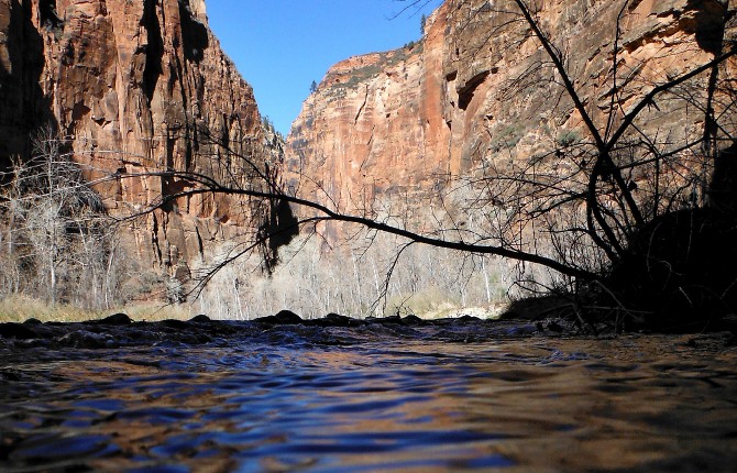
Toward evening. Shadow view from the river. |
||
————————————————————————————————— This essay was originally posted to National Geographic's Water Currents blog on July 1, 2015. ————————————————————————————————— Special thanks to Mike Large, Lead Park Ranger, Zion National Park, Division of Interpretation. —————————————————————————————————
I flow out of a cave at 9,000 feet elevation near Navajo Lake at Cascade Falls, Utah, descend toward Lake Mead at 1,000 feet, and empty into the Colorado River. The length of the Virgin River is 180 miles, however I am only the 33-mile stretch of the North Fork.
I could tell you tales of other parts of my course, but the favorite section of my journey is the 8½ miles through the steep Navajo sandstone canyon walls located in the Colorado Plateau Mojave Desert ecosystem of southern Utah at what is now called Zion (place of sanctuary and safety) Canyon, formerly known by its Paiute Indian name, Mukuntuweap or Mu-Koon’-Tu-Weap.
What is experienced as I travel the stretch from where the Zion Canyon Scenic Drive road ends at the Temple of Sinawava (a Paiute word for the Coyote God), until the South entrance at Springdale, is an amazing adventure! I have the opportunity to look up and view 3,000-foot high red rock walls, many of them with vertical charcoal and beige colored streaks created by moisture leaching out of the rock. |
||
 |
||
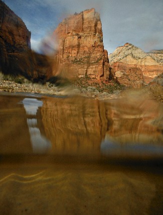
Zion canyon walls seen through river ice. Photo by Derek Irland |
||
I carved and sculpted and moved all this rock, with the assistance of my other shape-shifting forms -- rain, snow, sleet, and ice. My stream gradient, 50 to 80 feet per mile, is one of the steepest in North America. I am only one of the few remaining free flowing rivers left in the United States, and was designated Utah's first wild and scenic river in 2009, during the centennial celebration of Zion National Park.
Although there were other names given to me by various communities who lived along my shores for millennia, I am currently called the North Fork of the Virgin River. The reason why is not clear, but one supposition is that I was named “La Virgen” after the Virgin Mary by two Spanish Catholic Missionaries, Father Escalante and Father Dominguez in 1776. Or another theory is that Jedediah Smith named me after Thomas Virgin, who was a member of his 1827 team.
And speaking about names, in English I am called a river, but since thousands of international visitors come here every year, I hear many languages on a daily basis; río, irmak, flume, река, fleuve, flod, נהר, rivière, fluß, folyóba, sungai, song, upė, jõgi, lumi, and hundreds of other designations. Rivers are given specific names by the people who inhabit our shores and over the years the designations change, depending on who wields the most influence at any given time. |
||
 |
 |
|||
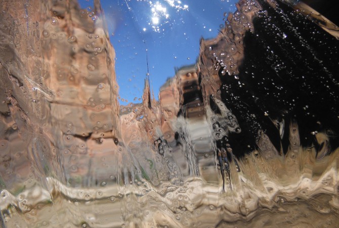
What the river sees. Photo by Derek Irland |
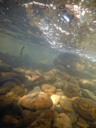
Riverbed underwater. Photo by Derek Irland |
|||
I provide sustenance for flora and fauna here in the Park, and even harbor endangered minnows, the Virgin River spinedace (Lepidomeda mollispinis), which are found nowhere else except the Virgin River Basin. Some of the trees that rely on my water for nourishment include Single Leaf Ash, Bigtooth maple, Fremont Cottonwood, and the Box Elder. The cottonwoods are especially prevalent and in springtime their fluffy seeds snow down to be transported on my current, and planted along the riparian corridor for future generations of Populus fremontii.
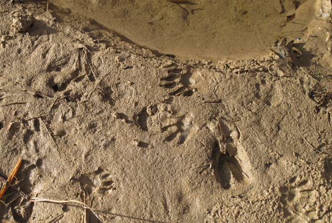
You can see the tracks of creatures who come down to my sandy banks to get a drink: There are Mallard Ducks, wild turkeys, Mule Deer, Great Blue Herons, Ringtail Cats, Bank Beavers, and Canyon Wrens. However, these days the most numerous prints left along the shores are of hiking boots and flip-flops. Some of the human foot prints are created by visitors, but others are my friends who help look after me year after year, including Mike Large, Lead Park Ranger, Zion National Park, Division of Interpretation, and all of the other staff who work for the Park Service. |
||
 |
||
Who comes to this river to drink? Tracks of mule deer (Odocoileus hemionus) and a ringtail cat (Bassariscus astutus). |
||
Most of the time my flow is fairly low, but sometimes after a heavy rain I can turn into a raging flash flood destroying roads and knocking out anything in the way. On December 21, 2010 I crested at 9.8 feet and went rip-roaring through the Park. My cfs (cubic feet per second) varies throughout the seasons. Without rain during the summer months, I average about 20-30 cfs. During the late summer monsoon season heavy rains can raise the flow up to 200-1000 cfs. The largest flow since 1926 was 9,100 cfs in December 1967. Whew, what a ride that was! One cubic foot is 7.4805 gallons of water and is about the size of a basketball. Zion Outfitter describes this by writing that on a “40 CFS day you could imagine 40 basketballs moving past you in 1 second.”
Because of the depth of the canyon, groundwater feeds numerous springs, providing flow throughout the year. However, my waters are not always clean, and sometimes I have over exuberant levels of Escherichia coli (or E.coli) within my system, most often caused by both human and animal feces.
At the Visitor Center near my shores there are two signs with important information. The first one reads: “Every time you fill your reusable bottle you keep a disposable bottle out of the landfill. Americans discard an average of 167 bottles each every year. If you put all of them end to end, they would circle the Earth 217 times.” And the second sign with a large photograph of a columbine flower says: “Zion’s water is naturally filtered through 2,000 feet of Navajo Sandstone. Drink the same water as the golden columbines in the park’s famous hanging gardens. But never drink untreated water directly from a spring.” |
||
 |
||
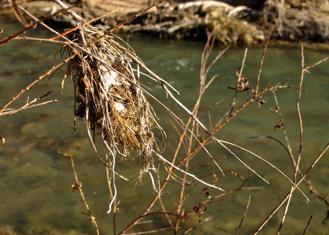
Litter hovels. River debris provides shelter for riparian spiders. |
||
When my flow is high I leave behind debris clumps of small leaves, twigs and interwoven grasses that get caught on low-lying limbs. As more detritus is added, these litter hovels have the appearance of bird’s nests found in bushes along my banks, which are good architectural shelters for riparian spiders. So, I provide sustenance for an enormous variety of flora and fauna who rely upon me for their very survival. And in all likelihood I will outlive them all. The Virgin River has been moving along downhill for so long and I have every intention to keep flowing for generations yet to come. |
||
next page: Yaqui River >
< previous page: Bagmati River