SINGAPORE RIVER, Singapore |
||
 |
||
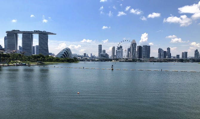
Singapore as seen from the Barrage, with Marina Bay Sands and the biodomes at Gardens by the Bay on the left and the giant Singapore Flyer Ferris wheel in the middle. |
||
————————————————————————————————— Special thanks to Dr. Shawn Kaihekulani Yamauchi Lum, Asian School of the Environment, Nanyang Technological University; Yap Wai Kit, Public Utilities Board, Singapore’s National Water Agency; Dr. Kira Alexandra Rose, School of Humanities, Nanyang Technological University; and Tan Beng Chiak, science teacher and former President of the Jane Goodall Institute (Singapore). —————————————————————————————————
As I enter the bay, a swan floats gently on my surface, taking in the view of downtown Singapore. Swans usually mate for life, but I don’t see this one’s partner. The lone bird doesn’t flutter or fly away and in fact, it seems to be anchored to a specific spot. Ah ha! This is no live creature, but rather a robot, called a NUSwan, or Swanbot, set up to monitor my water quality. It was jointly developed by the Public Utilities Board, the National University of Singapore’s Environmental Research Institute, and the Tropical Marine Science Institute. Five of these realistic, sculpted swans (an acronym for Smart Water Assessment Networks) transmit 6,000 to 7,000 data points a day to a collection center where information about my pH level, dissolved oxygen, oxidation-reduction potential and chlorophyll content will be used to construct environmental models.
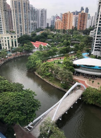
I am the Singapore River, and am only 1.98 miles (3.2 km) long from my “source”·at the Kim Seng Bridge to where I empty into the Marina Reservoir at the southern end of Singapore, an island country. It is strange to say that I begin at a bridge when my cousins around the world plot their origins as a spring, or glacier or snow melt, but if you study a map my name appears just after the bridge. However, for those who wish to explore, I actually extend another 2.4 miles (3.9 km) from Kim Seng Bridge to Queensway/Farrer Road with a mixture of open and covered drain, but my name changes to the Alexandra Canal, a constructed channel. |
||
 |
||
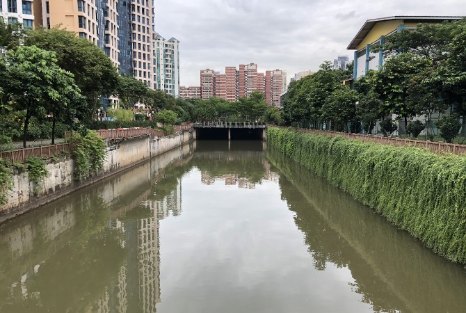
The beginnings of the Alexandra Canal, an extension of the Singapore River. Plants were added to help soften the appearance of the concrete walls. |
||
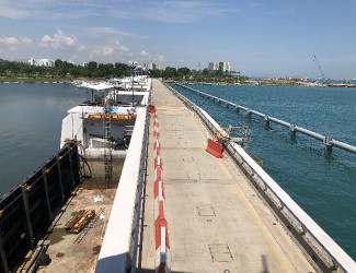
Once upon a time, I emptied into the Singapore Strait through a tidal estuary, but in 2005, a dam called the Marina Barrage was constructed to create a freshwater reservoir, alleviate flooding, and offer opportunities for recreation. The Barrage, a 1,148-foot (350 m) engineering marvel, spans the Marina Channel, allowing visitors to walk above both reservoir and sea. It also houses nine hydraulically operated steel crest gates and seven drainage pumps that help to modulate reservoir levels. |
||
 |
 |
|||
A view of the Marina Barrage. |
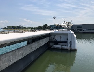
Visitors atop the Barrage will note the difference in color of seawater, left, and Marina Bay water, right. |
|||
 |
||
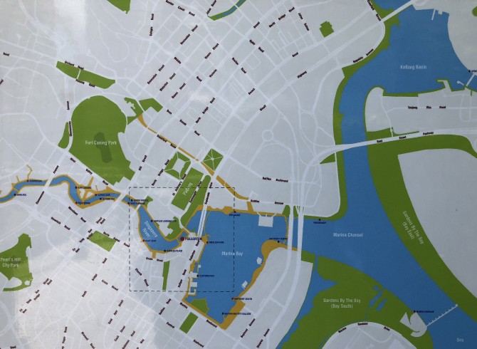
Map of Singapore River entering Marina Bay and then the Marina Channel. The barrage, which stops seawater, is at the lower right. |
||
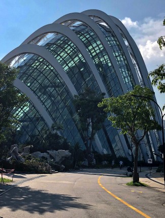
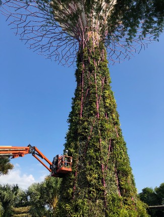
I’ve been allowed to keep a few of my natural meanders, but essentially, I am confined to a stone and concrete channel, am no longer subject to tidal influence, and very little about me is recognizable as a free-flowing “river.” The Marina Reservoir, too, is the result of human engineering, and is surrounded by reclaimed land built mostly from imported sand, plus soil and clay. Much of this new ground is home to Gardens by the Bay, which contains two large glass air-conditioned biodomes filled with plants and towering walkways. A prominent fixture of this park, “Supertrees” are massive pink metal vertical armatures that light up at night covered with mostly non-native vegetation, creating an artificial, constantly maintained display. Also built on this reclaimed land is the iconic architecture of the Marina Bay Sands. Opened in 2010, the three 55-story towers are topped with a boat-shaped structure that is prominent on the skyline of Singapore, which used to be known as the Garden City. That name has now coalesced into “City in a Garden,” which means that many office and residential locations are dripping with greenery and a network of nature reserves. It is mandated that new developments must have green spaces on the ground and higher levels of the building. There are also plants and trees lining almost every roadway and on the pedestrian walkways overhead.
More and more of Singapore’s wild regions have been lost due to urban expansion. Untamed, natural forests of yesteryear have been replaced by manicured gardens and ponds. Only 0.5% of primary forest lands are still intact. There are, of course, arguments on both sides since the designers of Gardens by the Bay admit that it was not an easy decision to relegate valuable downtown real estate to green spaces. |
||
 |
 |
|||
The Cloud Forest biodome at Gardens by the Bay. |
Giant cranes hoist workers up to add more plants to one of the Super Trees. |
|||
You may think the term “water scarce” refers only to places of arid desert, but equatorial Singapore is one of the most water scarce countries in the world. It has no natural lakes or aquifers and is physically too small to amass much rainwater. Out of necessity, the island nation has diligently explored ways to assure a reliable water supply, and the several techniques in use today are referred to as the National Taps.
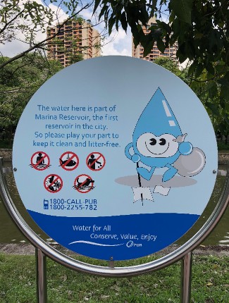
The first of these “taps” is local water catchments. Storm runoff is collected locally, routed through a network of canals, collection ponds, and waterways and added to the Marina Bay plus sixteen other reservoirs, most of which are impounded estuaries. And yes, this is where my small part in Singapore’s water supply equation comes into play.
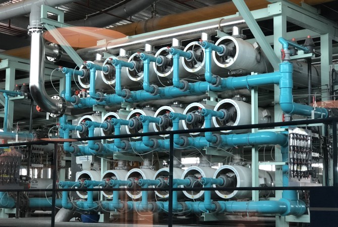
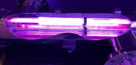
Introduced in 2003, NEWater is an additional national tap. It is wastewater that has been reclaimed under the supervision of Singapore’s national water agency, the Public Utilities Board, or PUB. Sewage and used water is subjected to a rigorous treatment process that includes dual membrane technologies such as microfiltration/ultrafiltration and reverse osmosis. It also undergoes intensive ultraviolet disinfection, producing exceptionally clean water that is utilized primarily for wafer fabrication plants and air-conditioning in industrial complexes and commercial buildings. NEWater is also added to the reservoirs during dry spells. |
||
 |
||
NEWater treatment facility. |
||
 |
 |
|||
NEWater ultraviolet light. |
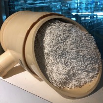
A cross section of one of the filtration systems. |
|||
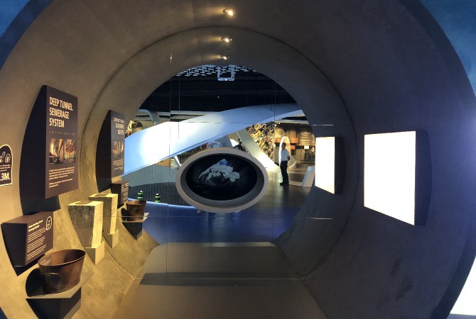
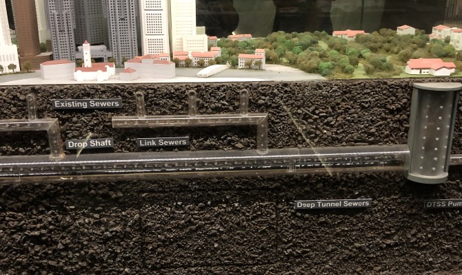
A massive construction project that is going on below ground in Singapore is the Deep Tunnel Sewerage System, a submerged superhighway that conveys wastewater via gravity through a series of large tunnels to treatment processing plants. The treated used water is then channeled for further reclamation into ultra-clean, high-grade reclaimed water called NEWater. Before this modern removal system, most households had a “night soil bucket” for collecting human waste. The contents were then emptied into my unhappy current. Whew! The filth and stench were difficult to tolerate! The practice of this night soil collecting was phased out in the 20th century, with the last households using this system holding out until the 1980’s. |
||
 |
||
Exhibit at Marina Barrage Sustainable Singapore Gallery showing the size of one of the pipes in the Deep Tunnel Sewerage System and a night soil bucket on the left. |
||
 |
||
Miniature display of the Deep Tunnel Sewerage System. |
||
Currently, imported water from Malaysia meets a rather large portion of Singapore’s human needs, but a contract for this imported water will expire in 2061 and will need to be renegotiated.
Another water strategy is desalinization, a process that removes salt from ocean water to make it potable. The first seawater reverse-osmosis plant in Singapore opened in 2005. There is certainly plenty of ocean available, but desal infrastructure is costly to build and requires large amounts of energy to operate. In addition, disposal of the waste discharge, known as brine, can negatively impact the environment, for it includes many harmful chemicals used in the desal process.
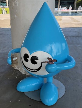
Conservation and education efforts complete this nation’s water acquisition program. PUB’s mascot, Water Wally, is a big, blue animated drop with arms and legs and a smiley face that appears everywhere around the country, from signage asking the public not to dump anything into my waters, to large bulbous sculptures located at strategic locations such as the information museum at the Marina Barrage. Water Wally also helps to promote the message that NEWater is pure and safe to drink. |
||
 |
 |
|||
River signage depicts Water Wally warning citizens not to pollute. |
Water Wally holding a miniature rain garden and a butterfly. |
|||
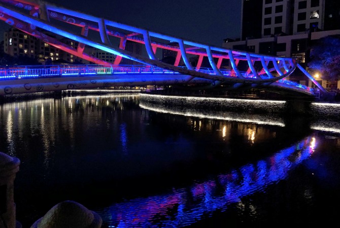
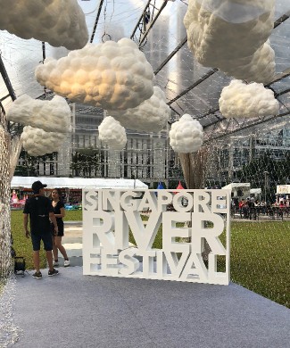
Thankfully, modern Singapore does still value its namesake river. Originally, just a few transportation bridges spanned my spine, but today there are numerous pedestrian bridges in multitudinous shapes that are brightly lit at night, offering easy access to tree-lined walkways, shops, cafes and restaurants on both my banks. There is even an annual river festival named after me, which aims to attract visitors to my shores for fun and celebration. In 2018, the festival’s theme was “Your River, Your Vibe,” and one event featured LED-illuminated kites shaped like manta rays flying in the air above me. |
||
 |
||
Alkaff Bridge at night. This bridge is shaped like a traditional river boat (tongkang) and is named after a prominent family of Yemeni-Arabs who settled in Singapore. |
||
 |
 |
|||
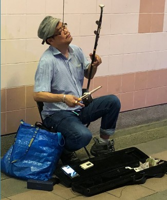
A street musician plays an urhu (erhu), a two-stringed Chinese instrument, beneath a bridge next to the river. |
The Singapore River Festival. |
|||
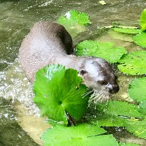
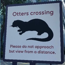
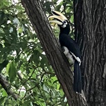
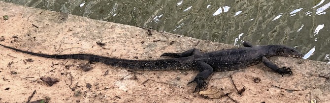
Despite all this teeming human activity, birds, including hornbills with their enormous beaks, still flock to me for sustenance, and my water is home to all kinds of riverine creatures, including monitor lizards and smooth-coated otters. Often considered an “indicator species,” otters need clean water to survive, so it is a true success story that families of Singapore River otters are thriving. There is an otter webcam where fans download photographs and videos, and all along my banks there are signs reminding people to keep their dogs on a leash, not to feed or harass the otters, and to refrain from putting sharp objects into my water. This is gratifying to me, for the lighthearted otter is among my favorite companions. |
||
 |
 |
 |
||||
A wild smooth-coated otter at the Singapore Botanic Gardens. Video still by Tan Beng Chiak. |
“Otters crossing” sign at Gardens by the Bay. |
Oriental pied hornbill (Anthracoceros albirostris). |
||||
 |
||
A Malayan water monitor (Varanus salvator). |
||
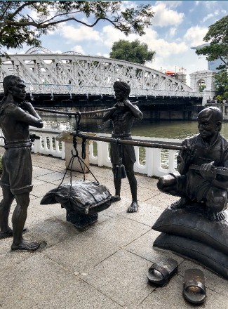
Short in length, but long on history, I’ve been host to continuous human settlement since ancient times when a thriving fishing village named Temasek was located at my mouth. By the late 12th Century, that town was renamed Singapura, meaning “Lion City” in Malay. In 1376, a Javanese Empire conquered an early civilization on my banks. Chief Temenggong Abdul Rahman and his followers established a small settlement on my left bank in 1811. Thomas Stamford Raffles, who understood the importance of a prosperous waterfront, founded modern Singapore in 1819 when he signed a treaty with the British East India Company, granting permission for a trading post here. Establishing Singapore as a “free port” brought thousands of immigrants to my shores. I was the island’s “bloodstream!” My banks were lined with godowns, warehouses where trade goods from China and India were stored, and my surface teemed with watercraft. Until the Barrage was built you could still see bumboats (flat-bottomed barges also known as lighters or tongkangs) ferrying cargo to and from large ships moored out in deeper water. (Today, these old tongkangs have been refurbished and turned into floating restaurants.) There are also small, oar-driven sampans, or kolek, still used for fishing and short-range transport of people and goods, but decades of waterfront rehabilitation have forced the majority of these traditional vessels into retirement. |
||
 |
 |
|||
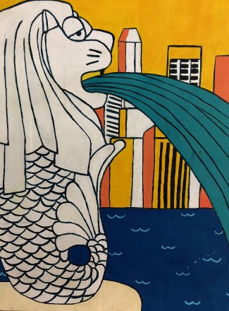
With the head of a lion and body of a fish, the Merlion has been used by the Singapore Tourism Board as an icon/logo for the city. |
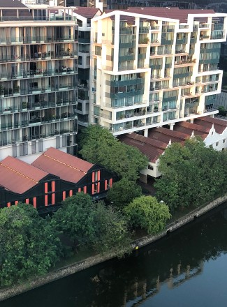
The historic warehouses (godowns) are now dwarfed by modern condos and apartment buildings. Most of them have been turned into shops and cafes. |
|||
We really cannot get away from the lesson of pollution, for hand-in-hand with thriving trade came congestion and contamination. Duck and pig farmers used me as a disposal system. So did the local food venders known as hawkers, and as industry developed, oil spills and toxins from boat-building factories sullied my water. Humans can be so ignorant and unthinking! They assume that I will carry away their wastes but the truth is that it will always come back around, for there is no away on this water planet!
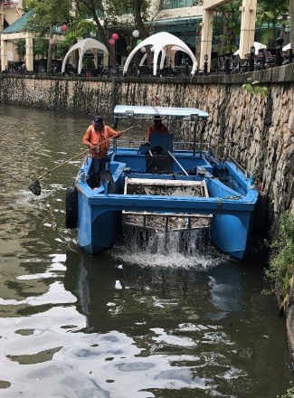
In 1977, Prime Minister Lee Kuan Yew proposed to give me and my cousins, the Kallang, Rochor, and Geylang Rivers, a thorough cleaning. It took ten years of coordination among numerous government and private agencies, and the expensive task involved relocating some twenty-six thousand families from slums to public housing, and relegating five thousand street hawkers and vegetable sellers to food centers, which are still a favorite inexpensive place for locals to eat instead of going to fancy restaurants. I had to endure the horrific dredging of foul-smelling mud and debris from my banks and the bottom of my streambed, but at least I was being cared for. Even after millions of dollars of rehabilitation, and a decade of healing work, the job of keeping me clean is ongoing. Special blue boats scour the length of my body daily to retrieve floating rubbish. Someday, I tell myself, people will learn not to litter, and there will be no need for trash boats. |
||
 |
 |
|||
One of the trash removal boats that scour the river each day. |
Some of the natural meanders in the river were left intact. This section of the river used to be soggy fields and mangrove swamps. |
|||
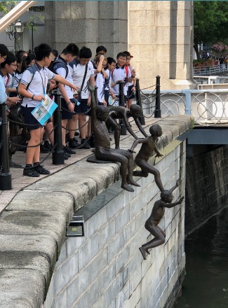
I am glad to be healthier, yet I yearn, just a little, for the noise and energy of earlier years. Along my flanks, a collection of bronze sculptures reminds visitors of the daily activities of people throughout history -- fishermen, financiers, merchants. One statue is of a group of naked boys leaping gleefully into my midst. I miss those children who plunged from tree branches and swam in a group for safety, avoiding the bumboats that churned me into waves. Times change. I’m not that river anymore, but I am still here, lending a hand as Singapore pioneers a more sensible relationship with water. And I am grateful to assist in a small way with the drinking water needs of this important nation that contributes globally to the future of water policy issues. |
||
 |
 |
|||
“The First Generation” sculpture by Chong Fah Cheong. |
Sculpture by Malcolm Koh, “The Great Emporium.” Indian and Chinese coolies weighing their trade goods. |
|||
next page: Seine >
< previous page: Gowanus Canal